
A selection of downloads - mostly maps - many that are my own designs, created to accompany a video series. There's also a few other maps that I've collected over the years and made available here.
 The Least Used Stations is where I visit and make a video for the least used station in a county, according to the statistics supplied by the Office of Rail and Road, which are usually published in December of each year.
So that you can see where the least used stations are, I've designed and created this Least Used Stations Map which is divided up into the counties in England. (Wales and Scotland are done using their overall Top 10 least used stations instead). This is the version for the 2021-22 period..
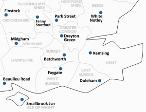
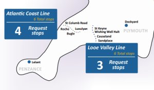 In the Request Stops series I'm getting round and visiting all the request stops in Great Britain to see what's at them.
To alight at a request stop you have to tell the guard on the train that you wish to do so, and to board at a request stop you have to 'make your intent clear' (by sticking your arm out!) as the train approaches the platform.
Here's the Request Stop map which shows you where on Britain's railways all the request stops are.
Latest Version - June 2026 - with 101 Request Stops
Previous Version - June 2021 - with 135 Request Stops
 This 2021 series visits sixteen locations in London where railways used to be, and to see what remnants and remains are left today.
This is the map that features in the series, you can download it here.
Don't forget to shout 'Allotment!' if you're playing along with the bingo game as well!
 You used to be able to buy a thick timetable booklet with all the timetables in the whole country in one publication, this was supplied with a fold out paper map with the the whole of the UK on one side, and localised areas on the reverse - they were and still are some of the best maps every produced for a clear guide of the railway system in Britain.
The last official map was published in 2013, someone took that PDF and edited it to create an update 2014, and then again in 2022 with more updates.
National Rail Map 2014 Version | National Rail Map 2022 Version
 These are the regional maps that were on the back - again, the London and South East version is again still one of the best railways maps that's ever been produced, but some parts are obviously out of date now.
Birmingham West Midlands | Cardiff and Bristol
Glasgow and Edinburgh | Liverpool and Manchester
Newcastle | Southampton and Portsmouth
This A3 sized poster PDF is a list of all the new stations opened since 2020.
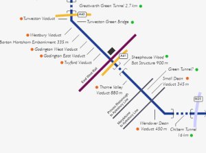 Myself and Chris from the Rail Focus channel have put together a diagram/map showing the route of HS2 and hopefully every bridge, viaduct, tunnel that is along the route - this is continually being tweaked and updated as more information comes in - thanks to everyone that has contributed feedback for this!
 To play along with the 'Bingo' game, download the End of the Line Bingo Sheet - essential for when it comes to viewing Episode No.20 at Wimbledon!
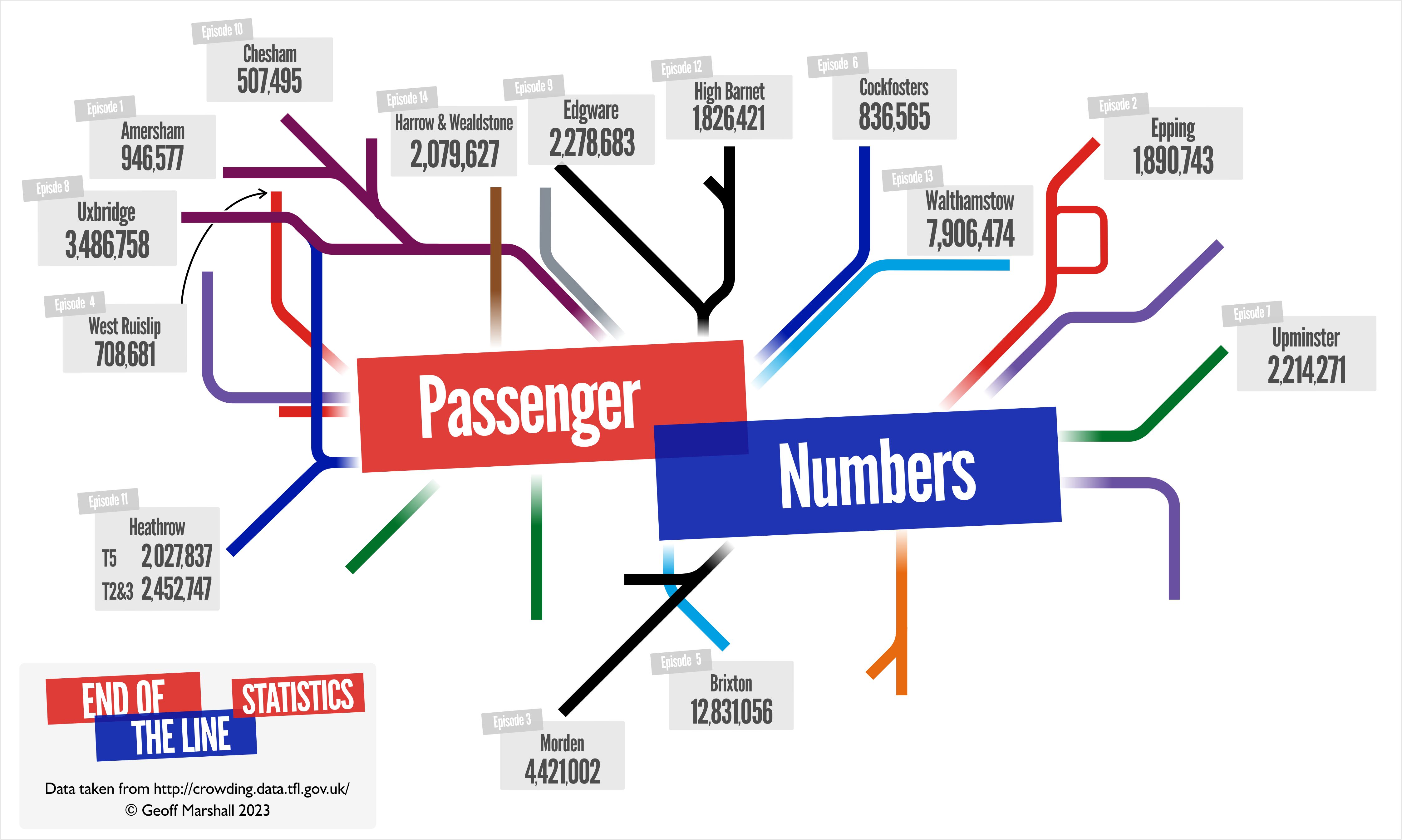
This 2022/23 series involves visiting stations at the end of Tube lines, and this map shows the locations visited along with the passenger statistics for each station so you can see what the most and least used stations are for those at the End of the Line.
 Other Tube Maps
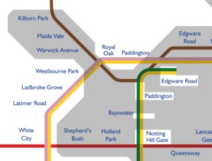
 The majority of the Tube network is actually in the open, so I created the Actual Underground Map that shows you which parts (shaded) are beneath the surface, and the rest of it which isn't.
Here's my Air Conditioned Tube Map. which shows which lines in London are cooled either by air conditioned trains, or air cooled trains.
For when it gets too warm in the summer! Map that shows which lines are air conditioned / air cooled because not all lines are - keeping you cool when travelling during the summer!
The Air Conditioned Tube Map 2026
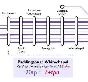 The Elizabeth Line / Crossrail opened on May 24th 2022 just between Paddington and Abbey Wood.
This is a 2021 map I designed projecting how I thought the service pattern might look.
In May 2023, with full running happening across the line, here's the map of the real service pattern showing where trains run and how often.
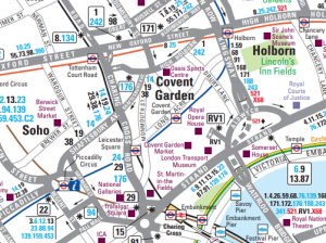 For many years TfL produced a Central London Bus Map, and four additional 'quadrant' maps, which showed all the bus routes in London - you could see in great detail which road were served by which numbered buses.
But these maps ceased to be updated in March 2016, the last time that TfL produced them, and since then there have obviously been changes to the bus network.
But a lot of it is still correct, and as they best bus maps for London that have ever been produced, I've saved them them and you can download copies here.
Central London | North West | North East | South West | South East
 London's new Express Orbital Bus Network is called Superloop, a network of buses in a circle around London.
But frustrated at the lack of a map that shows all the stops of the new routes, I thought I'd create my Superloop Map that shows all the stops that the services call at..
In addition, I've also created this Superloop Borough map, which show accurately the paths of the route within the Greater London boundary, and which London Boroughs they pass through.
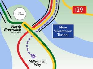 In April 2025, the new Silvertown Tunnel opened with brand new bus route SL4 running between Grove Park and Canary Wharf.
As there is also a Cycle Shuttle Bus running through the tunnel as well, I designed a simplified map showing what runs where with the existing Blackwall Tunnel, and new Silvertown Tunnel.
 For my Every London Bus project where I rode all 544 Bus Routes in London in January/February 2024 I produced maps, two of which are here.
This map shows the approximate location of every bus route in London to help you plan.
Whilst this How To Ride Every London Bus Map shows all the hubs/places that you'll need to go to in London if you're also trying to tick of all the bus routes!
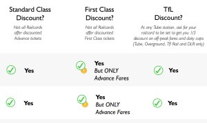 Here's a Railcards Guide Poster that is a guide showing all the differences between the different types of railcards and what discounts they can get you.